
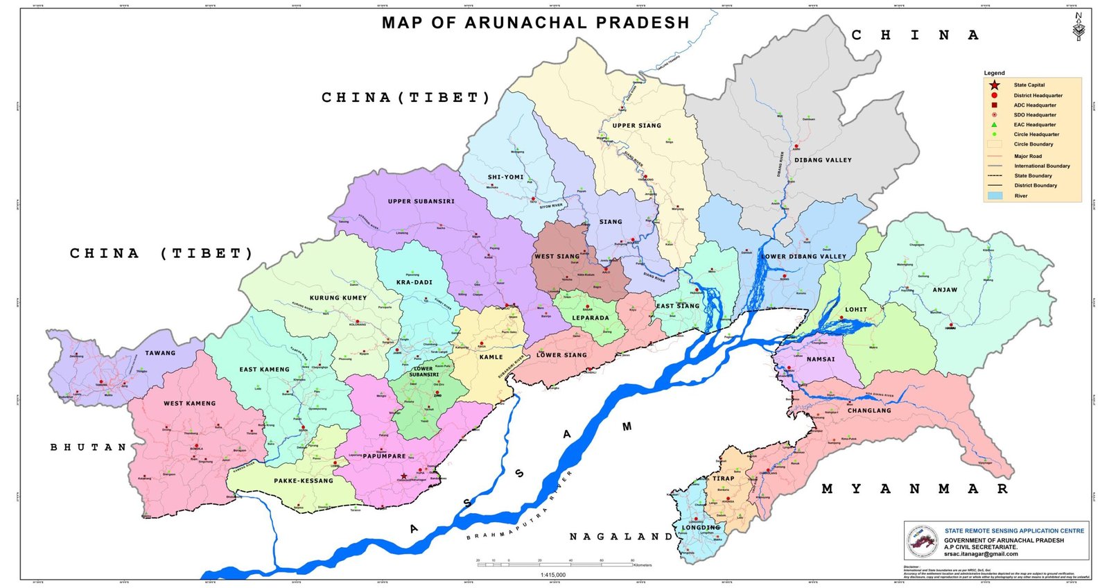
Tawang, the beautiful land of the people of Monpa Tribe, is located in the Western mostpart of the state Arunachal Pradesh bordering China and Bhutan. The district is entirely located amongst the mighty Himalayas and has a rugged terrain with deep valleys and altitude ranging between 3,500 to 22,500 feet. Its snow-capped peaks, pleasant lakes, congenial climate, friendly and hospitable people
Bomdila is well-recognized for its fantastic environment with apple orchids and Buddhist monasteries. Also, many trekking trails are available in this region that will make the trip of adventure seeker worthy. It brings the spectacular views of lush greenery and snow-covered Himalayas.
The three valleys namely Pakke-Valley, Pappu Valley and Passa Valley are worth seeing from the road top. The meandering rivers makes them more beautiful. On both the banks of the rivers paddy fields are grown
The name of this district is derived from the Kurung and the Kumey, the two principal rivers which flow through it.
The name of the district is derived from the two major rivers called Papum and Pare.
Pakke Kessang is a town in the Indian state of Arunachal Pradesh. It is located in Pakke-Kessang district, which has been carved out of the East Kameng district along with five administrative units.
The district was formed when Subansiri district was bifurcated into Upper and Lower Subansiri districts in 1987. Lower Subansiri district has a long ancient history related with the Chutiya Kingdom. It was probably under Chutiya chieftain rule from a long time, and came under Birpal’s rule in the 12th century.
Kra Daadi is a district in Arunachal Pradesh in north-eastern India. It was carved out of Kurung Kumey district on 7 February 2015.
The region is mostly covered by dense forest consisting Alpine, moist temperature tropical pine and temperate weather evergreen forests in upper, upper middle, middle and lower region respectively. The district is rich in flora and fauna.
District is created by bifurcating the West Siang district with its headquarters at Tato. The district would have four administrative units namely Mechuka, Tato, Pidi and Manigong.
Kamle got its name from the river Kamle. River Kamle joins the Subansiri river which finally meets the Brahmaputra in Assam.
Lepa Rada district, with headquarters at Basar, is one of the 25 districts of Arunachal Pradesh state in northeastern India. Lepa Rada falls under 29-Basar Assembly Constituency and 1-West Parliamentary Constituency
The homeland of various tribes like Galo, Minyong, Bori, Bokar, Pailibo, Ramos, Memba form a natural abode for many species of orchids, diverse flora & fauna endowed with a dense vegetation, and a wide range of climatic and geographical variations, the district enjoys a moderate and comfortable climate.
The homeland of various tribes like Galo, Minyong, Bori, Bokar, Pailibo, Ramos, Memba form a natural abode for many species of orchids, diverse flora & fauna endowed with a dense vegetation, and a wide range of climatic and geographical variations, the district enjoys a moderate and comfortable climate.
The homeland of various tribes like Galo, Minyong, Bori, Bokar, Pailibo, Ramos, Memba form a natural abode for many species of orchids, diverse flora & fauna endowed with a dense vegetation,
Famous around the world as one of the best white water rafting expeditions, it attracts adrenaline seekers
Dibang Valley district derives its name from the river Dibang which flows through it and finally debouches into the plains where it meets the Lohit River near Sadiya. The major tributaries of Dibang River are Dri, Mathun, Talon, Eme, Ahi, Emra and Awa. The district is a wild mountainous area and present remarkable topography.
The name of Lower Dibang Valley district is derived from the mighty river Dibang that flows through the heart of district and finally ends into the Brahmaputra
Anjaw is an administrative district of Arunachal Pradesh with its headquarters at Hawai. It is bounded on the north by China, on the west by Lower Dibang Valley and Lohit district, on the south by Changlang district and on the east by Myanmar.
In the easternmost tip our country lies this enchanting land namely LOHIT(also Lohit) district of Arunachal Pradesh which is known for its pristing scenic beauty. Lohit named after the mighty river that meanders across the mountaineous region from Tibet and enters India at DICHU village of KIBITHOO circle of Anjaw district and gushes down to meet the mighty BRAHMAPUTRA in the plains of Assam.
Picture large paddy fields, gentle rivers and gentler rivulets, sprawling tea plantations, clean wide roads, grand pagodas, massive Buddha statues, traditional bamboo houses, ethnic roadside eateries, charming little markets, handsome men and pretty women. That’s Namsai for you.
Changlang District, showered with Bio-diversity and covered with picturesque hills lies in the southeastern corner of Arunachal Pradesh, is the eastern most part of India, having international boundary with Myanmar (Burma), where the morning Sun light first touches the Horizon of the eastern Mountain ranges of the district while the rest of the Country still napping in their cozy beds waiting for the emergence of the dawn of the day.
Unique picturesque hills in the southernmost part of Arunachal Pradesh is Tirap District
Longding District was once a part of Tirap frontier agency which was created in 1943 covering some areas from Lakhimpur Frontier Track and Sadiya Frontier Track with administrative Headquarters at Margherita town in Assam.